Harbour/Fishing Industry
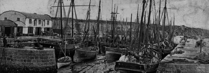
Kilkeel harbour is a relatively new harbour, with harbours at Annalong and at Derryogue (now gone) preceding it in importance. The harbour was first started in the 1850’s and a pier was built in 1868 with further improvements in 1872. The harbour could only accommodate 24 boats in the 1880’s. In 1885 the South Pier was constructed, followed in 1886 by the Old Dock. In 1916 it was extended to form the inner basin. There was further expansion in 1955 and the improvements continue to this day, with the installation of floating pontoons to accommodate small boats and a new slipway completed in 2008. The fleet grew to over 115 boats in the 1990’s and there has been a decline due to quotas and EU restrictions. Originally herring was the catch and then whitefish like cod and haddock. In the 1950’s they first started fishing for prawns or “creepy crawlies” as they were thought of locally. Now the whitefish fleet is depleted and prawns are the major catch, with an increase in catching crabs and lobsters. In recent years aquaculture is on the increase with the growing and harvesting of oysters and mussels in Carlingford Lough.
In the early days schooners traded with Liverpool, Scotland , Cornwall and Kinsale, trading goods such as potatoes, grain, granite and importing coal, etc. Kilkeel also was home for local boat builders and cooperages, as well as all the related trades needed to maintain boats.
There have been many seafaring disasters over the years, with the great fishing tragedy of 1843 when 73 fishermen were lost off the County Down coast, 27 of which were from Mourne. Then there was the Connemara and Retriever collision in Carlingford Lough in 1916 when 94 souls were lost. During the First World War, in 1918 a German submarine sunk a number of local fishing boats, after allowing the fishermen to escape safely to the shore. There have been many disasters and fishing remains a very dangerous occupation. There is memorial to all those lost at sea in front of the Nautilus Centre at Kilkeel Harbour.
Maritime/families at sea
Mourne Maritime Visitor Centre
First Floor, Nautilus Centre, Rooney Road, Kilkeel, tel (028) 4176 2525
The Mourne Maritime Visitors Centre tells the story of the local fishing and maritime heritage. There is a reconstruction of a wheelhouse where children both young and old can have a go at being skipper and learn about life on board. It also houses the “Anna” skiff which was the pride of the herring fleet when Kilkeel was also home to tall ships that carried granite and grain to ports all over the UK and Ireland. Whatever the weather you can sit and enjoy panoramic views of Kilkeel harbour. There are craft activities for children when they visit, as well as gifts to browse through. Lift and stair access available.
The Families at Sea exhibition is a great way to trace your relatives, with the fishing and maritime histories of over 20 local families on display. There are over 100 photos and details on display of those registered who were connected to fishing or were mariners at the beginning of the 19th century.
RNLI Lifeboat Station
Visitor Contact:
Sadly Kilkeel has seen more than its share of tragedy on the seas in the past number of years. Kilkeel RNLI Lifeboat Station has been in operation since 1986 and covers an area with the largest fishing fleet in Ireland. The present station was built in 1992 and has since undergone extensive modifications. The launching davit has been replaced with a larger one to facilitate the new Atlantic 85 lifeboat, Frank William Walton, which was placed on service in 2006. Many a seaman has been glad to see the men of the Kilkeel lifeboat arrive on the scene. Lives have been saved and many helped.
Churches/church-related:
The Old Church of St Colman’s and Graveyard
The Old Church represents the historic monument from which Kilkeel takes its name, translated to mean “The Church of the Narrow Place”. Its location, on an elevated narrow site, would appear to confirm this. Dating back to the 14th Century, the church was dedicated to St Colman and was known in 1388 as “St Colman Del Morne”. Within the grounds of the church there is a defaced equal armed medieval cross, which stands beside a granite socket stone, which was traditionally used as a wart well for curing warts. A detailed historical description of the tradition, folklore and structure of the church and surrounding graveyard are available on the interpretive boards in the graveyard.
Mourne Presbyterian Church
Mourne Presbyterian Church was completed in 1831 at a cost of £850, replacing an old thatched three corner church which was built in 1756 and a former meeting house constructed in 1736 at the upper end of the present graveyard. The present church has been improved and renovated on several occasions. Within the grounds, in front of the church, is an old sundial which was presented to the congregation in 1757 by the son of the first known Minister of Mourne, Rev Charles Wallace. In 1923 a War Memorial was placed in front of the church. A marble figure representing a soldier with arms reversed stands on a granite base and marble pedestal. The unveiling ceremony was performed by the Rt Hon The Earl of Kilmorey and the Very Rev Major General Simms. Adjoining the church is a lecture hall which was opened originally as a school in 1853. This building is now used as a church hall.
The Church of Christ
The Church of Christ the Redeemer, Church of Ireland was consecrated in the year 1815. It stands between Newry Street and Mountain Road. It has been considerably improved since it first opened. Tablets in the church include one to the soldier and explorer General Francis Rawdon Chesney of Packolet House, Ballyardle. He was born at Ballyveagh Annalong in 1789 and died at Packolet just outside Kilkeel in 1872. He devoted the last 20 years of his life to literary and scientific pursuits, including the furtherance of the great project of the Euphrates line to India and the surveyance of the feasibility of the Suez Canal which now links the Mediterranean with the Red Sea. He is buried in the cemetery at Christ Church. The graveyard also contains graves of many other local notables, including the Kilmorey family and Robert Scott (d 1961) who won a VC in the Boer War.
St Colman’s RC Church (Massforth)
The Church of St Colman (Massforth) is the Roman Catholic Church which stands about a mile from Kilkeel on the Newry side of the town. It is close by the Mass Rock used in the Penal days and replaced an earlier small chapel. It was completed in 1879, replacing an older building dated 1810, and was designed by architect John O’Neill & Byrne. The church was erected through the dedication of the Very Rev Richard Marner DDPP VF who was born in the parish of Kilmore 1834. Mr Marner was Professor and President of St Malachy’s College Belfast (1857-1876) and Parish Priest of Upper Mourne (1885-1906). He also led the building of the Church at Atticall; Parochial House and Hall on Greencastle Street, Kilkeel; St Colman’s; Star of the Sea and Atticall Schools. He died in 1906.
In the field behind the cemetery there is a “Kistavaen” or “Giants Grave” which is of significant archaeological interest.
Parochial House/Oratory/St Colman’s Hall
The Roman Catholic Parochial House on the corner of the Manse Road was built in 1890 on a site formerly known as “The Circus Field”. Our Lady of the Angels Oratory is a small church built at the beginning of the 1960s. It replaced an older building and is a minor Roman Catholic chapel to the main St Colman’s Church on the Newry Road. St Colman’s Hall, positioned beside the Oratory, was once the parish centre for concerts, dances and drama up until recent years. It is now used as a youth facility. St Colman’s School replaced Dunavan School on the Newry Road in 1963. The boys and girls schools amalgamated in 1989.
Mourne Abbey
The name Mourne Abbey refers to a Moravian religious house originally located here dating from 1763. The community was built up mainly by Brother James O’Harril, who was not ordained, but ministered there from 1797 until 1807, when he died and was buried here. It dwindled over the next 10 years. There was originally a graveyard behind the house; however this has been covered over the last century, leaving the last headstone which is now built into an outhouse wall. The inscription reads: “O’Harril – The Rev’d James O’Harril, born in Drumall Feb 27 1739 – departed June 10 1807”. The old buildings were incorporated soon after into the house of Quinn Henry who was agent to the Kilmorey Estate. This Victorian house is presumably the “delightful summer residence” referred to in the “Picturesque Handbook” (1846).
The Alfred Eadie Hall/Kilkeel Presbyterian Hall
The United Brethren Meeting House on Newcastle Street, now the Alfred Eadie Hall, was originally a Moravian Church until 1916. It was erected in 1832 and its foundation stone with the inscription “Church of the United Brethren 1832” is built into the porch of the present day manse. It was then used as a church hall by Kilkeel Presbyterian Church, which is further down Newcastle Street beside the Housing Executive. The church was formed by the Secession Presbytery of Markethill in 1822. The present church replaced an older building at the end of the 19th Century. In recent years it has undergone extensive renovations and had a steeple added.
Banks:
Danske (formerly The Northern Bank)
Situated on Greencastle Street, this is a Victorian house which was previously the Belfast Bank established in 1868.
First Trust
The First Trust Bank, also situated on Greencastle Street, was formerly the Provincial Bank which amalgamated with the Munster and Leinster Bank in the early 1900s. It is on the site of two former cottages. The Munster and Leinster Bank was formerly situated in the building adjoining Christ Church House which was built in the 1920s.
Schools:
St Louis
St Louis Grammar School was founded in 1921. It was previously known as “Thornmount” which was owned by McClymot who had sawmills there. Additions were made to the school in 1973 and it now houses 573 pupils (1999). There is an old fort behind the school which is of rich archaeological interest.
Other:
Kilmorey Arms Hotel/Kilmorey Square
At the top of Knockchree Avenue is the Kilmorey Arms Hotel which has provided lodgings and accommodation since before the 1850s. In the 1800s the Market House and Court House were also situated at the top of the present day Knockchree Avenue where a market was held every Wednesday and fair held on the first Tuesday of every quarter. Long cars and horse drawn coaches once collected and deposited passengers from the Court House and offices. With the arrival of motorised buses, Norton & Co Bus Depot was situated in one of these buildings. The Court House was also a neutral meeting place where “Penny Readings” concerts and dances took place in the 1800s and early 1900s. The Market House was demolished in 1952. Kilmorey Square was recently improved as part of a major Environmental Improvements Scheme to the town in 1999 and is the location of an old watering trough which dates back to the 1800s. The trough was a gift to the town by Ellen Constance Lady Kilmorey and was originally situated at the corner of the Harbour Road and Bridge Street. It was used by cattle, horses and sheep until the 1960s when it was removed to its present site. A memorial statue was erected just below Kilmorey Square in 1999.
The Lower Square
The site was formerly a Church of Ireland School House “Kilmorey National School” dating back to the 1840s, which was demolished and replaced by a Parochial Hall in the 1950s. The Hall was opened on 31 July 1958. The modern Lower Square was constructed in 1997 as part of a major regeneration initiative for Kilkeel. The sculpture “Narrows Journey” was erected in 1998 and depicts the rich heritage and culture of the Kilkeel area linked to the fishing, farming and granite industries.
Hanna’s Close
Hanna’s Close is a cluster type settlement or ‘clachan’ of eight restored cottages with lanes, steps and paths maintained as they had evolved over several centuries. This type of settlement pattern was the norm in late medieval Ireland but was gradually replaced by scattered individual farms as enclosures progressed from 1650 onwards.
Haulbowline (Cranfield) Lighthouse
Haulbowline is a main sea light and also serves to guide vessels from seaward through the entrance channel into Carlingford Lough. It is built on a wave-washed rock, exposed only at low tide.
The lighthouse was built after a request was made in 1817 to the Corporation for Preserving and Improving the Port of Dublin (the Belfast Board) by the merchants of Newry to replace the 1803 Cranfield Point Lighthouse due to the latter’s poor position in marking the dangerous rocks at the entrance to Carlingford Lough and also its inadequacy for the guiding of vessels at the west end of the Lough. Cranfield Point Lighthouse tower subsequently became a victim of coast erosion and tumbled into what had become the foreshore in the early 1860s. The lighthouse keeper’s cottage remained and was later converted into a private residence and can still be seen today, identified by its characteristic tall black chimneys.
Greencastle/Newry Street
At the end of Greencastle Street the public house “Jacob Halls” is the site of one of the oldest houses in the town, which was known formerly as O’Hagan’s and dates back to the 1700s. At the bottom of Newry Street (John Quinn Limited; McErlane) at numbers 4-6 are two listed buildings which date back to 1790. Originally a three-storey five-bay house with one extra at the western end, the ground floor is now in shops fronts but the upper floors are all Georgian-glazed. The house was the former home of Dr Adderly.
HISTORICAL INTEREST
Greencastle Castle
Built in the 13th century by the Anglo-Normans under John de Courcy, Greencastle has a colourful past. It was taken by Edward the Bruce, brother of Robert the Bruce, in 1316, attacked at least twice by the Irish in late 14th century and maintained as a garrison up to 1590.
Opening times: open July & August
Admission: free
Greencastle Pier
There are still the remains of Greencastle Pier where many local people started their long journeys to America, Canada or Australia. They would have sailed across Carlingford Lough to Greenore and then took a boat to Liverpool and then onwards. The Pier is now privately owned.
The Kilmorey’s
The Mourne Park estate, about two miles outside Kilkeel on the Newry Road, was inherited by the Kilmoreys as indirect descendents of Nicholas Bagnall who, in the 1550’s, had been given all that belonged to the Abbey of Newry and the Lordship of Mourne.
There were Viscounts of Kilmorey from 1625 and Earls of Kilmorey from 1822. Some lived at the estate and others were absentee landlords, but from the mid-1800’s onward the 3rd and 4th Earls lived fairly constantly at Mourne Park. On the death of Lord Kilmorey in 1961 his nephew, Major Patrick Needham heir presumptive, waived his right of succession. Ironically his son, Sir Richard Needham, the 6th Earl, was destined to serve as a Minister of State in the Northern Ireland Office from 1983-1992.
Giant Murphy
Patrick Murphy, better known as Giant Murphy, was born in a cottage close to “Cassy Water”, three miles from Kilkeel on the Newry Road. He was eight feet ten inches high and was very popular and loved by all his neighbours.
He was persuaded to travel abroad with a type of travelling circus and was in Britain, America and Europe. He died at an early age of twenty six and was buried in Kilbroney cemetery.
General Chesney (Francis Rowden) – ‘Father of the Suez Canal’
Francis Chesney was born at Ballyvea, Kilkeel, in 1789. He joined Woolwich Military Academy when he was fourteen and went to Portsmouth as a 1st Lieutenant when he was sixteen.
The Chesney family moved to a new house which they built themselves at Ballyardle in 1822. The house was called ‘Packolet’, named after a river in South Carolina.
In 1829 Francis, now a Captain, went on a mission to Egypt and while there he became absorbed in the possible construction of a canal linking the Mediterranean with the Red Sea. Chesney surveyed the Isthmus of Suez and concluded that the construction of a canal was feasible.
The French acted on his report and, when the canal was officially opened in 1869, he was invited by M. de Lesseps to the great meeting. To Chesney’s surprise and gratification, M. de Lesseps took him by the hand and, leading him forward, said, “Messieurs, je vous presente l’homme a qui nous devons le Canal de Suez – M. le General Chesney – le Pere du Canal”.
His great ambition though was to link Europe with India by an overland route via the Euphrates River. He took leave of absence at his own expense and after successfully completing the expedition to test the navigability of the Euphrates, he returned to England but the government did not implement his plans. An Honorary Doctorate was conferred on his by Oxford University and he received medals from the Royal Geographic Society and the Royal Society.
In 1859, when the general retired at the age of seventy-five, he returned to Mourne where, with his wife, three sons and two daughters, he took up residence at ‘Packolet’ and led a very active life.
It was a familiar sight to see the Chesney family walk the two miles to church on Sundays while the servants often travelled in the family carriage.
General Chesney died in 1872 at the age of eighty-three and is buried in the cemetery at Christ Church, Newry Street.
Burke & Hare – William Hare
Best known for his notoriety, William Hare, with an accomplice William Burke, was responsible for no less than sixteen murders from 1827 to 1828 in Edinburgh. Hare had a lodging house in Edinburgh and when an elderly lodger died owing rent, Hare and Burke decided to recoup their loss by selling the lodgers body to one of the medical schools of anatomy, which were normally serviced by ‘body snatchers’. They received £7.10s and were so encouraged by this amount that they conspired to “hasten the demise” of sixteen victims until, becoming overconfident, they aroused the suspicions of neighbours and were arrested. Hare turned Kings Evidence in exchange for his freedom and, while Burke was executed, Hare fled the angry mobs to Ireland and chose Kilkeel, which was then fairly isolated. He was soon an inmate of the local Workhouse and was recognised by a Doctor Reid who had been a medical student at Edinburgh. When Hare died he was buried at the Burial Banks behind the old Workhouse, which was situated at the upper end of Newry Street.
Link to Titanic
There was a young man who lived in Newry Street and he was on board the Titanic when it made its first and final journey across the Atlantic. He was employed as a steward and was lost on that fateful night.
Aeronautical link
From early days Cranfield had links with the aeronautical industry when Captain Alcock landed his plane on Cranfield East Beach in 1933 to visit his aunt who lived in one of the houses along the shore bank. He was one half of the famous partnership of Alcock and Brown who were the first to fly the Atlantic. During the Second World War 600 acres of ground was requisitioned to create Greencastle Airfield, or the aerodrome, as it locally known. Here American troops were stationed and also at Mourne Park. It was an important servicing, maintenance, storage and training depot for planes and the American Army Air Force. Indeed, General Patton addressed the troops and Mrs Roosevelt, the Present of America’s wife, officially opened the facility on 11th November 1942. The famous Memphis Belle landed for repairs during the War. 37 homes were demolished to build the aerodrome. You will see walls in the locality made from the broken up runways around Cranfield.
Granite industry
The Mourne Mountains are the source of the famous Mourne granite. It was exported around the world in the last couple of centuries and indeed Liverpool is largely paved with Mourne Granite. Mourne was home to many skilled stonemasons. There are a number of local granite firms who have many years experience in working the stone, including Linton’s, Robinson’s, McConnell’s and Cunningham’s, to name a few. McConnell’s now work on international commissions, having made Princess Diana’s Memorial in London and work on the 9/11 Memorial in New York.
The Crawtree Stone Dolman
This dolman in Kilkeel came to be known as The Crawtree Stone. Heading out of the town on Newcastle Street there is a mini-roundabout. From the car park at Asda store you can see a laneway and it is located there on private ground.
Kilfeaghan Dolman
The dolman, a Neolithic portal tomb approximately 5000 years old, has a massive capstone, which is estimated to weigh 35tons. The capstone is believed to be one of the biggest in Ireland. Excavations carried out at the turn of the century unearthed various bones and pottery. From Kilkeel going towards Rostrevor you will see a brown sign for Kilfeaghan Dolman on the right hand side of the road.
NATURAL/WILDLIFE
Mourne Mountains
An area of Outstanding Natural Beauty, the Mourne Mountains are the most picturesque in Ireland and were the inspiration for the writer C S Lewis’s magical land of Narnia in his popular children’s books The Chronicles of Narnia. In this compact range, 15 miles long and 8 miles wide, only a dozen of the sixty or so individual summits rise above 2,000ft, with Slieve Donard, at 2,769ft, the highest peak in Ulster.
Mourne Wall
It took over 18 years to complete the granite wall. Started in 1904, it was not completed until 1922. The wall is 22 miles in length and at places 8ft high and 3ft wide. Many walkers in the Mournes use the wall as a marker. The wall begins and ends at the Silent Valley Reservoir.
Silent Valley
Silent Valley Mountain Park, Head Road, tel (028) 9035 4716
The Silent Valley Reservoir was built to gather water from the Mourne Mountains and is the main water supply source for most of County Down and a large part of Belfast. Ringed by mountains, ‘The Vallet’, located within the Mourne Area of Outstanding Natural Beauty, houses beautiful parkland, lakes and a pond. It attracts around 50,000 visitors per year most of whom come to enjoy the peace and solitude of this mountain area with its unique landscapes and varied wildlife. Northern Ireland Water has provided a number of visitor facilities at the site including a restaurant, information centre, conference centre and education centre – all housed in two old colonial style bungalows and enjoying delightful views over the parkland.
Opening times: The reservoir grounds are open daily from 10.00am-6.30pm (summer) and 10.00am-4.00pm (October-April)
Admission Fees: payable on entrance. Car, on foot, child
Directions: vehicle access is possible only through the main gates located on Head Road. Drivers are required to obey the one-way traffic system which leads to a single large car park at the south end of the reservoir grounds. A shuttlebus also operates during peak season.
Spelga Dam
Once the grazing ground for Irish red deer, part of Deer’s Meadow was flooded to create Spelga Dam, completed in 1957, to maintain a supply of water for the many mills along the River Bann. Deer’s Meadow delimits the geological divide between the Eastern or High Mournes (which drain into the Irish Sea) and the Western or Low Mournes (which drain into Carlingford Lough). In the past cattle would have been taken here to graze pastures in the summer months and then brought down again at the end of September, a practice known as transhumance or ‘booleying’ locally.
Kilkeel Town & Heritage Trails
In 1740 Harris, in his History of County Down, described Kilkeel as “a small village and a church situated between the foot of the mountains of Mourne and the sea, in a narrow vale, which extends for some miles along the coast: the soil good, and the country well inhabited”. Steeped in a strong industrial tradition of fishing, farming and granite, Kilkeel takes its name from the old church overlooking the town, it being the anglicised version of the Gaelic “Cill Choal” dating back to the 14th Century. Kilkeel is the principal town in the Kingdom of Mourne.


Follow Us